Wednesday, August 8, 2012
82°31.457’ W
43°16.167’ N
Lexington State Dock
Lexington, Michigan
 |
View from our slip at
Belle Maer Harbor |
 |
| Leaving Belle Maer Harbor |
Our goal today was to reach the port of Port Huron. The weather was clear and wave height was reasonable. Our problem today was, we were slowed by the 6 mph current until entering Lake Huron. Once in the wide open lake our speed returned and we pushed on for an additional 20 miles.
 |
| Ferries crossing |
 |
| Ship's we waited for |
On the way we saw fuel for $4.06 a gallon and thought it a mistake but it wasn’t so stopped and topped off. We were told that as soon as the fuel truck arrived the price would be raised to what ever he had to pay plus markup.
When we entered the main river we were met by two ships that crossed directly in front of us. Considering how big they were I laid back and watched them pass in review.
 |
| Industry along St. Clair River |
 |
| Boat house |
We made another 65 miles today and wonder when the weather will turn on us. The weather predictions are not good for the rest of the week so ------- stay tuned!
 |
| Homes along St. Clair River |
 |
| Entrance into Port Huron |
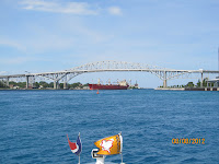 |
Blue Water bridge connecting
USA and Canada |
 |
| Lake Huron |
 |
| Entering Lexington State Harbor |
Barb and I took time to walk into the town and enjoy a pizza. What we saw was an all American small town that was fun to visit.


No comments:
Post a Comment